Title Under Header

.
Showing posts with label Map of Philippines. Show all posts

Thursday, November 14, 2013

Typhoon Haiyan

===.
Quote of the day:

I learned to give not 
because I have MANY...
but because I know how it 
feels like to have NOTHING.

===.
Aid must reach Philippine typhoon victims faster: UN
POSTED: 14 Nov 2013 14:41

The United Nations admitted on Thursday that its response to the typhoon disaster in the Philippines had been too slow, amid reports of hunger and thirst among desperate survivors.

• Picture Caption 1:
People cover their noses from the stench of dead bodies in an area affected by Typhoon Haiyan in Tacloban, Philippine. (AP Photo/Dita Alangkara)Residents queue up for flights by military C-130 planes out of the airport in Tacloban, Leyte province, central Philippines. Thousands of people jostled and begged for seats on scarce flights out of the ruined city. (AFP/Ted Aljibe)


MANILA: The United Nations admitted Thursday that its response to the typhoon disaster in the Philippines had been too slow, amid reports of hunger and thirst among desperate survivors.

The UN's humanitarian chief, Valerie Amos said “the scale of the disaster and the logistics challenges it posed meant that six days on from the storm, some places remained without help.”

"There are still areas that we have not been able to get to where people are in desperate need," she told reporters in Manila "I very much hope that over the next 48 hours that that will change significantly."

"I do feel that we have let people down."

Criticism is growing over the pace of aid to Tacloban and other areas that were splintered by Typhoon Haiyan when it swept through the central Philippines last Friday.

Bodies still litter the streets of Tacloban, while others lie putrefying in body bags outside the broken city hall, awaiting mass burials.

Thousands of desperate survivors are clamouring to get out of a place where clean drinking water is in short supply and many have no shelter.

"The situation is dismal. Those who have been able to leave have done so. Many more are trying. People are extremely desperate for help," Amos told reporters in Manila.

"We need to get assistance to them now. They are already saying it has taken too long to arrive. Ensuring a faster delivery is our immediate priority."

However, she added: "There are thousands (of them) but we would never make the claim that we would be able to get to everyone."

Amos, who visited Tacloban on Wednesday to see the scale of the disaster, said her staff felt frustrated that supplies were stuck in the capital Manila.

The Philippines' shaky infrastructure took a battering in Typhoon Haiyan, one of the strongest storms ever to make landfall.

Many roads were left impassable, cluttered by debris from broken buildings that were destroyed when the ocean surged ashore.

The Philippines government said Wednesday that all roads were passable, but relief was still choked on Thursday, with fears over security after earlier attacks on aid convoys and widespread looting.

"Part of the job I have is to recognise the challenges we face but obviously (also) overcome those challenges and we have not been able to do that fast enough," conceded Amos.

"There are very good reasons for that but the fact that there are good reasons for that isn't enough. I think members of the government I met in the last few days feel exactly the same way."

• Picture Caption 1:
Path of Typhoon Haiyan


Where is 'Tacloban, Palo'?
The following Maps will show you where 'Tacloban, Palo' is.

Click on Map to Enlarge:

This Map shows 'Kawayan' in the Bottom Right.
'Tacloban, Palo' is below Kawayan and it's not shown here, but in the Maps that follow.

https://blogger.googleusercontent.com/img/b/R29vZ2xl/AVvXsEiS0gQ0khA-FbnEKeclrfzQtckD3KdsbHVjDgEwu_ZNc35H7Kx-Rrx8U9EQT2jdAYJ9le8P8Yrs4d4cWY4zuRtNEP5be4ePGyNtJ6KPXFTFYJt6OFKazJGHmE08LkVATFwvp8R4/s1600/Map+of+Philippines+with+Manila%252C+Cavite+%2526+Bicol-774456.jpg


===.

Thursday, October 31, 2013

Map of Philippines with Manila, Cavite & Bicol

===.
---------- Forwarded message ----------
Date: Thu, Oct 31, 2013 at 11:37 AM
Subject: Map of Philippines with Manila, Cavite & Bicol

Map of Philippines with Manila, Cavite & Bicol

When I found the Map, 
I came across this info about retiring in Philippines, 
just something to think about.

===.
Update: 2013 Nov 14

I read the the news that said that 'Typhoon Haiyan' will hit 'Makati' but now the news reads that it hit 'Tacloban, Palo' instead. Click HERE to read all about it.

===.
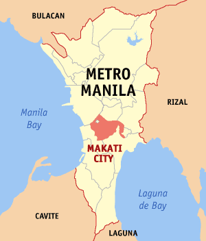
Makati

From Wikipedia, the free encyclopedia
http://en.wikipedia.org/wiki/Makati
http://upload.wikimedia.org/wikipedia/commons/f/fe/Ph_locator_ncr_makati.png


===.

Map of Philippines with Bicol Region

===.
.
===.
Bicol Region
From Wikipedia, the free encyclopedia

The Bicol Region (Filipino: Kabikulan; Spanish: Bicolandia) is one of the 17 Regions of the Philippines, designated as Region V. Bicol (also spelled Bikol) is composed of four provinces in the Bicol Peninsula, the southeastern end of Luzonisland, and two island-provinces adjacent to the peninsula.[2] The regional centre is considered to be in Legazpi City, Albay.[3][4]


Geography

The Bicol Region is located in the southernmost tip of Luzon Island, the largest island in the Philippine archipelago. The total land area of the region is 18,054.3 km2 (6,970.8 sq mi),[5] which or 5.9% of the total land area of the country. Around 69.3% of the total land area is alienable and disposable while the remaining 30.7% is public forest areas.[2]
The region is bounded by Lamon Bay to the north, Pacific Ocean to the east, and Sibuyan Sea and Ragay Gulf to the west. The northernmost province, Camarines Norte, is bordered to the north by the province of Quezon, thereby connecting the region to the rest of Luzon.

History

Albay's archaeology shows concrete evidence of trade with China, Malaya and Indonesia going back two thousand years. The first Spanish contact was in 1565, when a treasure-galleon returning to Cebu from Acapulco, Mexico, was swept off course and the captain recorded his awe at the sight of Mt. Mayon erupting.[cit

Language

Further information: Bikol language
The people of the Bicol region, called Bicolanos, speak any of the several languages of the Bikol sociolinguistic language, also called Bikolano, an Austronesian language closely related to other Central Philippine languages such as Cebuanoand Tagalog. Bicol languages include the Inland Bikol of Bikol-Rinconada (Rinconada area), Bikol-Cam. Sur (Buhi, Cam. Sur; Libon, Oas, Daraga, Albay and Donsol, Sorsogon), Bikol-Pandan (Northern Catanduanes). Standard Bikol is based from the coastal Bikol language of the dialect of Legazpi City and is understood widely throughout the region even though they cannot speak it fluently.
Bikol is the dominant language of the region. The Filipino language (Tagalog) is also spoken in northern parts of Camarines Norte as well as in the municipality of Del Gallego, Camarines Sur. Two Visayan languages, Sorsoganon and Masbateño or Minasbate, are spoken in Masbate and Sorsogon; they are collectively referred to as Bisakol.

Religion

The region retains Roman Catholicism as the overwhelming religion of the great majority. The Catholic religion has the highest number of followers than any other area in the Philippines.
Fiestas (Feast day of saints) are annual celebrations of parishes, from a simple barrio fiesta honoring a patron associated for good harvest, to a town fiesta honoring a miraculous saint, a diocesan fiesta like the feast of Our Lady of Salvation, or a regional one such as the Our Lady of Peñafrancia Fiesta, a week-long celebration to honor the Virgin Mary, dubbed as the "Patroness of Bicolandia". It is widely acknowledged that in Luzon, it is Bicol Region that holds the most number of men entering the seminary for Catholic priesthood, or women entering the religious life to become Catholic nuns.[citation needed]

Geology

Bicol region is volcanic in origin and part of the Pacific Ring of Fire. Known as the Bicol Volcanic Arc or Chain, the volcanoes are the results of the Philippine Sea Plate subducting under the Philippine Mobile Belt, along the Philippine Trench. Volcanism is evident by the number of hot springs, crater lakes, and volcanoes that dot the region starting from Mount Labo in Camarines Norte to the Gate Mountains in Matnog, Sorsogon.[14] Mayon Volcano is the most prominent of the volcanoes in the region, famous for its almost perfect conical shape and for being the most active in the Philippines. Its eruptions have repeatedly inflicted disasters on the region, but during lulls in activity, it is a particularly beautiful mountain. The southernmost tip of the peninsula is dominated by Bulusan Volcano, the other active volcano in the region. Tiwi in Albay and the Bacon-Manito area between Sorsogon and Albay are the sites of two major geothermal fields that contribute substantially to the Luzon Power Grid.[15][16]
Mayon Volcano, the highest at 2,463 metres (8,081 ft), is also the most popular in the region for its beautifully symmetrical cone. It is also the most active in the country.[22] The volcano is one of the protected areas of Region V under the name Mayon Volcano Natural Park encompassing 5,776 hectares (14,270 acres).[18]
===.
.